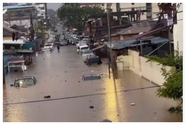
Heavy rains that began late on Sunday, June 28, 2026, and continued into the morning of Monday, June 29, 2026, have caused widespread flooding across parts of Accra, submerging major roads, inundating homes and disrupting traffic during the morning rush hour.
Several roads became impassable as floodwaters rose rapidly, forcing motorists to drive through submerged sections while others abandoned their vehicles altogether. The flooding also affected businesses and residential communities, with residents rushing to move their belongings to safer locations.
Authorities have urged motorists to avoid flooded roads and advised residents in flood-prone areas to remain vigilant as more rainfall is expected.
The areas reported to have been badly affected include:
- Sections of the N1 Highway
- Apenkwa towards Tesano
- Dzorwulu
- Accra–Kasoa stretch
- Weija
- Afienya
- Mallam
- Gbawe
- Achimota
- Apenkwa
- Tetteh Quarshie Interchange
- Mahama Road
- Odorkor
- Accra–Nsawam stretch
- Awoshie
- Dome
- Spintex
- Atomic (Madina)
- Kaneshie
- Darkuman Junction
- Tse Addo
- Manet
- Abeka
- Lapaz
- Burma Camp
- Lister Area
- Hajj Village
- Parts of the Kwame Nkrumah Interchange
Accra’s recurring flooding challenges have largely been attributed to inadequate drainage infrastructure, poor waste disposal practices and rapid urbanisation, which continue to increase the city’s vulnerability during periods of heavy rainfall.
Meanwhile, the Ghana Meteorological Agency has forecast more rainfall of varying intensity across parts of southern Ghana, including the coastal belt, warning that weather conditions are expected to persist throughout the day.